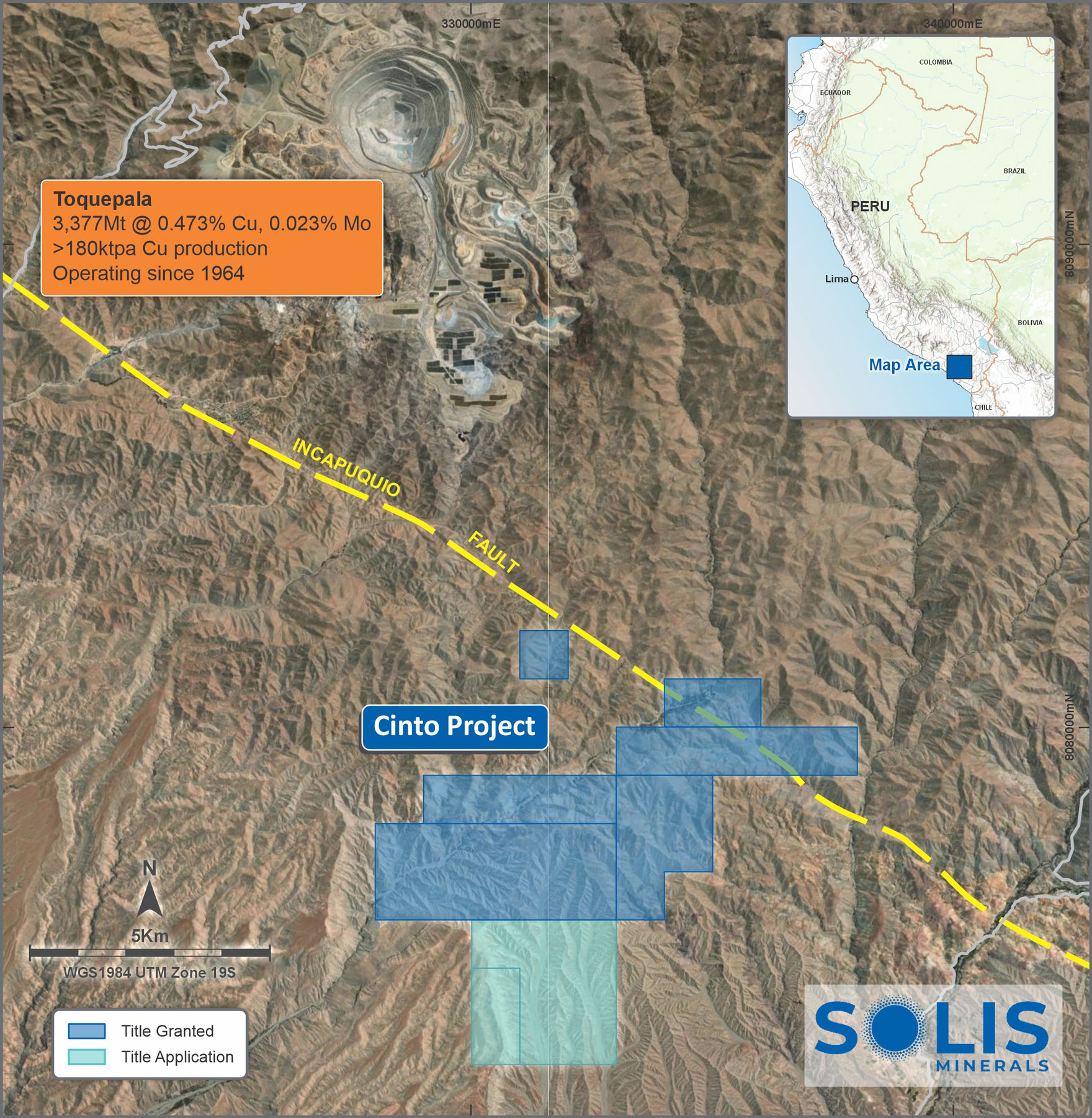
Cinto Copper Project
The Cinto Copper Project consists of seven tenements totalling 3,200ha in the highly prospective southern Peruvian Copper belt, located some 15km to the southeast of the world class Toquepala Au/Ag/Cu/Mo Porphyry Mine.

Solis has completed a first pass geochemical programme at the Cinto Project and has finalised an access agreement with the local community to fast-track drill exploration at this location.
Initial surface grab samples have reported assays up to 7.14% Cu with mineralisation mapped over a 200m x 100m area in historical workings associated with significant alteration and structural deformation.
Cinto Geology and Mineralisation
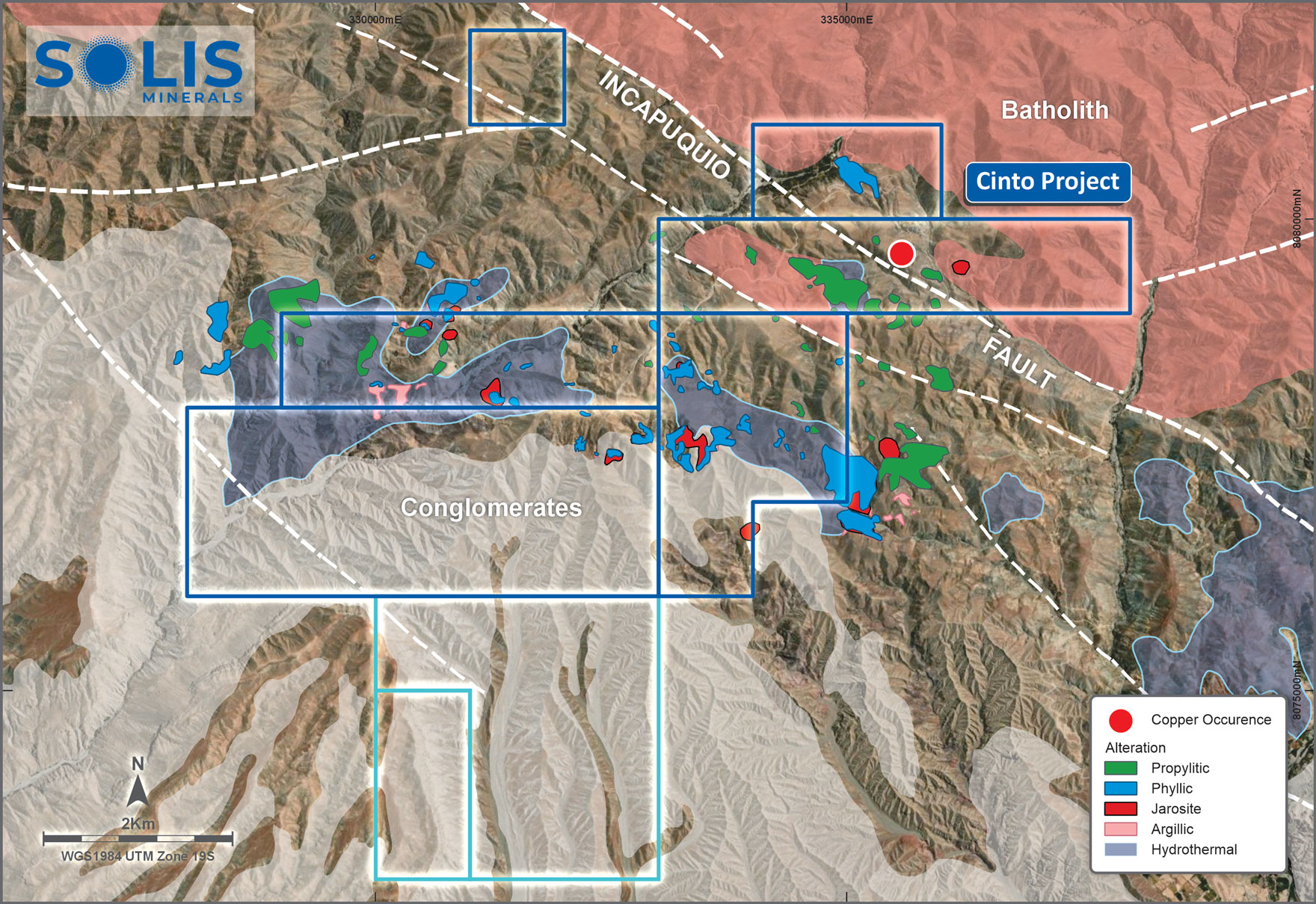
The Cinto Project is traversed by the transcurrent Incapuqio fault system which is a major regional structure trending N125E (NW-SE) that is at least 400km long and up to 10km wide in places.
Late Cretaceous-Early Palaeogene intrusions related to the formation of major porphyries (Cuajone, Quellaveco, Toquepala) were probably favoured by the transcurrent nature of the Incapuquio fault and the zone and its margins form a focus of mining and exploration in southern Peru. The Cinto Project is situated in Toquepala Group volcanic and volcanosedimentary rocks which are coeval (same period) as the intrusives in the area and host the Toquepala porphyry.
The fault is the limit of the Oligocene Moquegua Formation basin to the south-west and conglomerates occur in the southern margin of the project.
Local geology of the project is dominated by the Incapuquio fault system in the north-west that juxtaposes Cretaceous batholith rocks to the north against coeval volcanosedimentary shales, lavas and tuffs to the south. Splays and parallel structures cross the permits in the south. A zone of hydrothermal alteration crosses the centre of the permits. In late 2022, Solis carried out Worldview-3 satellite imaging and identified several distinct zones of alteration. The south of the permits are covered by the edge of the Oligocene basin with shallow to moderate thicknesses of conglomerates. The altered rocks extend beneath this cover and are considered valid exploration targets
Cinto Geochemical Programme
Initial mapping programs have identified a zone within and bordering the Incapuquio Fault system that shows the presence of abundant copper oxides with artisanal workings.
Several assays returned copper values greater than 1% and one high grade sample returned 7.14% Cu in a highly mineralised oxide zone. Some mineralised structures are at high angles to a bounding splay of the Incapuquio fault to the north. The nature of the occurrence (mineralisation breccias, abundant copper oxide mineralisation in places) suggests a proximal source.
Geochemical results (associated Ag, Au, Mo and zinc) reflect a chemistry similar to the neighbouring Toquepala deposit. The copper occurrence is being considered as a marker for a potential porphyry style mineralisation in the area.
The Company has since arranged for mapping crews to be mobilised to site to systematically cover the entire tenement package and identify areas of highest prospectivity. The thin conglomerate cover in the south of the granted permits will be covered by drone magnetometry as field observations indicate the alteration continues southwards in this area. Follow-up Induced Polarisation (IP) geophysical studies will be carried out over areas of interest to evaluate primary drill targets.